Wildlife Walk 3 – Peppers Green
A walk of about five miles along hedge lined green lanes running through an arable landscape,with habitat corridors, ponds, birds, and the ghost of a lost Orchid. Very muddy in winter, best done in summer or autumn. The walk begins and ends in Uttlesford, but crosses the border into neighbouring Chelmsford Borough. Maps OS Landranger 167 or Pathfinder 1098 and 1122. No refreshments near the walk, nearest pubs are a drive away at, Good Easter or High Easter.
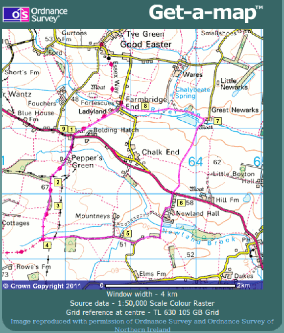
1. START at the layby on the A1060 at Salts Green TL621109. Cross the A1060 with care to follow a lane signed to Peppers Green Only. Continue along this lane passing Peppers Cottage and at Old Cris Field where the lane forks, pass to the right and in front of the cottage to proceed along the Byway marked with a red arrow. Continue along this old green lane with its thick hedges, keeping an eye out for birds.
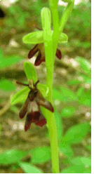
Fly Orchid © Tony Morton
2. You come to a small woodland on the right, which is Hardy’s Plantation. Until 1980 this was the site of the Fly Orchid, the last site for the species in Essex, but thereafter the path became very well used and the verges trampled. Eventually in 2009 the County Council resurfaced the path and dumped spoil on the verges, and the Fly Orchid is now extinct here and in the whole of Essex. There is still a faint chance that it might return from buried seed, so look around in late June when it is in flower, and if you do find it let Essex Field Club know through their website (see Links page).
3. Continuing further on you pass Roots Spring, another small woodland which should be good for spring Wildflowers but is badly misused by motorbike scramblers. The small woods that you meet on this walk are also places where deer can be seen, including Roe and Muntjac. Whilst deer are always attractive, they also pose a problem for wildlife conservation, because their numbers are now at record high levels, and they eat wildflowers to extinction. It seems we can have deer or wildflowers but not both.
4. At the T junction turn to the left into a field to walk along the field edge marked by a blue arrow to show it is a bridleway. This path enters another hedged area which continues uphill passing another small wood on the right hand side, Skreens Wood, eventually meeting a roadway.
5. Proceed in the same direction, until at a sharp right hand bend by Maiden Hall leave the road and turn left to walk in front of Quarles. Continue on this footpath taking the sharp left hand turn at a field edge and by a bridge, to reach a field. Walking the short distance northwards along the edge of this field cross the bridge over a stream to reach Newlands barn on the right. Take the signposted bridleway on the left to walk out on the avenue of Lime trees on the driveway to Newlands Hall.
6. Turn left to walk up to the A1060, carefully crossing this road to a signposted bridleway opposite. Follow this path until it opens out into a small field. Bear diagonally right towards Great Newarks, walking in front of the house, until at the end of the fence by a pond turn left to walk at the side of the water, (with the house now behind you).
7. There is a group of ponds here, providing a valuable habitat in the arable landscape. You may see Herons and ducks, and in high summer dragonflies. The River Can still has a population of Water Vole. Go into a wooded area to walk alongside the River Can and the ponds associated with it, to reach an open field. Walk along the edge of the field keeping the hedge to the right-hand side and when this goes sharply to the right leave it and continue in the same direction across the field to reach a bridge, which crosses Chalybeate Brook.
8. Cross the bridge and walk directly across the field in front, aiming at the end of the hedge in the distance. Continue to follow the hedge until reaching a stile at the roadside at Farmbridge End. Cross and turn left, proceeding over a bridge across the River Can to take the signposted Byway on the right. Walk up this path to return to the A1060 at Salts Green, where the walk began.
9. As a little extra, walk carefully westwards along the northern verge of the A1060 and you will very shortly come to a Special Roadside Verge, marked by timber posts with white plaques, which has a good range of wildflowers that are associated with the neutral or slightly chalky soils here.