
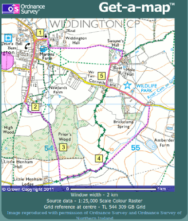
Wildlife Walk 1 – Widdington
A walk of about three and a quarter miles through green lanes, ancient woodland and passing by summer wildflower meadows. OS Explorer Sheet 195. Starting from Widdington TL538317
START at the triangular village green in Widdington, (map point 1 ) and note that among the trees planted here the southernmost tree on the green is a Wild Service tree, Sorbus torminalis, a very rare native species usually associated with ancient woodland in southern England. This is a good opportunity to see the tree and its distinctively shaped leaves.
2. Walk southwards along High Street and note in passing the Fleur de Lys pub to your left which might be useful at the end of the walk. Continue straight on ignoring roads off to the left and right into Wood End where houses stand in large gardens. Where the road effectively ends look for the footpath that goes off to the left along a broad track, and follow this through a green lane. This type of old lane is distinctive of Widdington parish which has many of them, representing tracks that go back many centuries and maybe even many thousand years. The hedgerows on each side make a valuable habitat corridor through the modern countryside. Such hedges can be dated by the number of woody species that you find in them; count the number of species in a 30 yard stretch and each species represents 100 years.
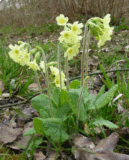
oxlip, a species of ancient woodland
3. Eventually you enter Priors Wood, an example of the ancient woodland of north-west Essex. The term “Ancient” has a particular meaning when applied to woodland; it means that there is evidence of the site being continuously woodland since 1600, and many such woods are considerably older than this, and may never have been cleared from the Wildwood that formed naturally after the Ice Ages. In historic times Priors Wood would have been managed as “coppice”, and cut down every 7 to 15 years to provide small wood for fuel, fencing and other products, with larger trees left as “Standards” to provide beams for constructing buildings. Priors Wood is now being managed again, large areas having been coppiced and felled in recent years. However there is a problem with regrowth of the felled areas, because of browsing by Deer which have eaten everything that they can reach. Fallow and Muntjac Deer may well be seen in this wood, and while it is nice to see such animals they are also a huge problem. Deer have no natural predators and they are now present in “un-naturally” high numbers, eating all the wildflowers and tree seedlings. In such woodland trees are not regenerating from seed, a problem for the future of this wood. If mankind does not step in to control deer numbers they will eat all the regrowth and effectively destroy the wood, as they have already destroyed all the flowers that we should be finding on the forest floor, like the now very rare Oxlip, which you may find the odd plant of along this path.
4. When you reach the far side of the wood descend the slope across an arable field. Then go on to the Byway which follows the headwaters of the River Cam or Granta, and turn left to follow it upstream. The track is sunken into the surface of the landscape providing a cool humid shady corridor through the countryside. Look for waterside plants in this distinctive habitat. When you come to a footbridge crossing the river you have a choice of routes.
ROUTE A. Cross the river on the footbridge and follow the footpath northwards beside an arable field. Eventually look out for the point where you cross a ditch coming in from the right-hand side, and the path starts to climb up a shallow slope. The grassland in the small field to your right is one of the last unimproved species rich grass meadows which remain in Uttlesford, containing a range of flowering species characteristic of chalky to neutral soils. As you continue on to a hard surfaced farm road look at the verge on the left where the farmer has created a strip of wildflower grassland with a full selection of all the species typical of chalky soils, the perfect opportunity to check out your plant identification skills. Note that both these wildflower grasslands flower in June and are then mown off in mid-July, the optimum management for the benefit of the flowers. At the end of the track is Cornells Lane where you turn left and follow the lane.
ROUTE B. For a shorter walk missing out the wildflower meadow continue to follow the green lane beside the river until you reach the road – Cornells Lane.
5. Walk westwards along Cornells Lane back towards Widdington. When you reach the junction with the first lane running northwards, Mole Hall Lane (or if you used route B and reach Cornells Lane at this point) take this lane towards Mole Hall. Ignore signs for the Wildlife Park which is now closed down. This quiet lane ends at Mole Hall, where you ignore the Bridleway that continues straight on, and you take the footpath to the left beside Swaynes Hall. After about 100 metres another footpath runs off to the left, which you take. This runs across arable fields and beside Widdington Hall and leads then through to the Church, an attractive building. Return to the beginning of the route at the village green.